2222")


Why Backpacking in Utah is Unforgettable
Utah. The name itself conjures images of staggering landscapes – fiery red rock arches defying gravity, deep canyons carved over millennia, and snow-capped peaks piercing impossibly blue skies. For the intrepid backpacker, Utah isn’t just a state; it’s a sprawling, diverse playground offering some of the most unique and rewarding backcountry experiences on the planet.
Whether you’re drawn to the sun-baked sandstone labyrinths of the south or the wildflower-strewn alpine basins of the north, Utah delivers adventure in spades. This guide is your compass to navigating the incredible backpacking opportunities across the Beehive State. We’ll delve into the distinct characters of Southern and Northern Utah, highlight some must-do trails, cover essential planning considerations, and equip you with the knowledge to embark on your own unforgettable journey.
Get ready to lace up your boots, hoist your pack, and discover the raw, untamed beauty that awaits off the beaten path in Utah.
Before You Go: Essential Considerations for Backpacking in Utah
Utah’s environments are as demanding as they are beautiful. Proper planning isn’t just recommended; it’s crucial for a safe and enjoyable trip. Here’s what you need to dial in before hitting the trail:
Permits, Permits, Permits!
- Why? To manage impact, protect fragile ecosystems, and ensure a quality wilderness experience.
- How? Permit systems vary wildly. Some are lottery-based months in advance (e.g., The Zion Narrows, Coyote Gulch), some are reservable online on specific dates (e.g., Canyonlands), and others might be available via self-serve kiosks at trailheads (less common for popular multi-day trips).
- Action: Research specific permit requirements for your desired trail LONG before your trip. Check official websites (NPS.gov, BLM.gov, FS.usda.gov) for the managing agency of the land you plan to visit. Failure to secure a permit can result in hefty fines and being turned away.

This cannot be stressed enough. Many of Utah’s most iconic backpacking destinations, especially within National Parks, National Monuments, and popular wilderness areas, require permits for overnight stays.
Seasonality is Everything
Utah experiences distinct seasons, and the “best” time to backpack depends heavily on where you’re going.
- Southern Utah: Generally best in Spring (March-May) and Fall (September-November). Summers (June-August) are dangerously hot (often exceeding 100°F/38°C), increasing dehydration risk and making hiking arduous. Flash floods are also a significant danger during summer monsoons (July-September). Winters can bring snow and ice to higher elevations and cold temperatures, but lower elevation hikes can be pleasant.
- Northern Utah: Primarily a Summer/Early Fall season (July-September). High elevation trails in the Uintas and Wasatch are typically snow-covered until late June or even July. Mosquitoes can be intense in early summer (July). Afternoon thunderstorms are common in summer. Fall brings stunning colors but also the possibility of early snowstorms. Winter backpacking is possible but requires specialized gear and avalanche knowledge.
Water: The Desert’s Gold (and Mountain Necessity)
Water availability is a critical planning factor throughout Utah.
- Southern Utah: Assume water sources are scarce, unreliable, and often silty or alkaline. Perennial rivers (like the Virgin or Paria) exist, but smaller springs marked on maps can dry up. You must know where reliable water sources are located on your route and carry sufficient capacity (often 4-6+ liters per person per day). Always treat water – filters can clog easily with silt; consider pre-filtering (e.g., with a bandana) or using chemical treatment/UV purifiers as a backup or primary method.
- Northern Utah: Water is generally more plentiful in the mountains from lakes and streams, especially earlier in the season. However, some ridge hikes or later season trips might still require careful planning. Always treat water from any source.
Safety First: Navigating Utah’s Challenges
- Heat: In Southern Utah, hike during cooler parts of the day (early morning, late evening), wear sun protection (hat, sunglasses, sunscreen, loose light clothing), and manage electrolyte intake.
- Flash Floods: Especially in Southern Utah’s canyons, check weather forecasts meticulously. Be aware of conditions upstream, even if it’s sunny where you are. Have escape routes planned if hiking in narrow canyons. Never camp in a wash.
- Altitude: Northern Utah trips often involve high elevations (8,000-13,000+ ft). Acclimatize properly if coming from sea level. Know the signs of altitude sickness.
- Navigation: Trails aren’t always well-marked, particularly in desert terrain or less-traveled wilderness areas. Carry a map, compass, and GPS device (like a satellite messenger or phone with downloaded maps), and know how to use them. Route finding skills are essential in many areas.
- Wildlife: Be aware of rattlesnakes (common in the south), bears (mostly in the north – store food properly), and mountain lions (rare encounters, but be aware). Moose are common in Northern Utah and can be aggressive; give them plenty of space.
- Remoteness: Cell service is often non-existent. Carry a satellite communication device (like a Garmin inReach or SPOT) for emergencies. Leave your itinerary with someone reliable.
Leave No Trace Ethics
Utah’s ecosystems, both desert and alpine, are fragile. Adhering to Leave No Trace principles is non-negotiable.
- Plan Ahead & Prepare (Covered above!)
- Travel & Camp on Durable Surfaces (Use existing trails and campsites. Avoid trampling vegetation or cryptobiotic soil in the desert – it’s alive!)
- Dispose of Waste Properly (Pack it in, pack it out – ALL trash, including toilet paper and food scraps. Know how to properly dig catholes for human waste, or use WAG bags/portable toilets where required, especially in canyons).
- Leave What You Find (Don’t take artifacts, rocks, or wildflowers).
- Minimize Campfire Impacts (Use established fire rings where permitted. Consider using a camp stove instead. Be aware of fire restrictions, which are common).
- Respect Wildlife (Observe from a distance, never feed animals, store food securely).
- Be Considerate of Other Visitors (Keep noise down, yield on trails).

Southern Utah Backpacking: Canyons, Red Rock, and Desert Solitude
Southern Utah is a world of sandstone wonders, sculpted by wind and water into a landscape that feels both ancient and alien. Expect sun, heat, limited water, and awe-inspiring geology.
The Zion Narrows (Zion National Park)
- The Experience: Arguably the most famous canyon hike in the world. Wading, and sometimes swimming, through the Virgin River as canyon walls tower thousands of feet above. Jaw-dropping beauty at every turn.
- Routes:
- Top-Down (16 miles): Typically done as an overnight trip (requiring a permit) or a very long day hike (also requires a permit). Starts at Chamberlain’s Ranch (requires a shuttle) and ends at the Temple of Sinawava.
- Bottom-Up (Up to Orderville Canyon/Big Springs): Can be done as a long day hike from the Temple of Sinawava as far as Big Springs without a permit. Go as far as you like and return. Good taste of the Narrows.
- Difficulty: Moderate to Strenuous, depending on water levels and distance. Constant wading on slippery rocks is tiring. Cold water temps are possible.
- Permits: HIGHLY competitive lottery system for overnight trips, plus day-use permits for Top-Down day hikes. Bottom-up day hikes (to Big Springs) don’t need a wilderness permit but do require park entrance. Check Zion NPS website for exact details and lottery dates – plan months ahead!
- Best Season: Late Spring/Early Summer and Fall. Summer brings high flash flood risk.
- Key Considerations: Requires sturdy, closed-toe shoes that drain well (rental gear available in Springdale), neoprene socks recommended, trekking poles essential for stability. Check flash flood forecast immediately before entering.
Coyote Gulch (Grand Staircase-Escalante National Monument)
- The Experience: A spectacular non-technical canyon hike featuring stunning natural arches (Jacob Hamblin Arch, Coyote Natural Bridge, Stevens Arch), waterfalls, and lush riparian vegetation contrasting with the surrounding desert slickrock. Usually involves wading through the Escalante River or Coyote Creek.
- Routes: Multiple entry/exit points (Hurricane Wash, Crack-in-the-Wall, Fortymile Ridge/Water Tank) allow for loops or point-to-point trips of varying lengths (typically 13-26 miles).
- Difficulty: Moderate to Strenuous. Involves hiking in sand, wading, some minor scrambling, and potentially navigating a steep friction pitch or using a rope bypass depending on the route (e.g., Jacob Hamblin Arch exit).
- Permits: Required for overnight stays, obtained via Recreation.gov. These are also competitive, especially for popular weekends in spring and fall. Group size limits apply. WAG bags (human waste pack-out systems) are REQUIRED.
- Best Season: Spring and Fall. Summer is very hot.
- Key Considerations: Water is generally available from the creek but needs treatment. WAG bags are mandatory. Navigation skills needed, especially for accessing different trailheads.
Paria Canyon / Buckskin Gulch (Paria Canyon-Vermilion Cliffs Wilderness)
- The Experience: Buckskin Gulch is one of the longest and deepest slot canyons in the world, offering a sustained, dark, narrow, and incredibly committing experience. It joins the wider, but still stunning, Paria Canyon. Expect long stretches of wading, potential deep pools (chokestones), and very limited escape options in Buckskin.
- Routes:
- Paria Canyon (38 miles): Typically done top-down from White House Trailhead to Lee’s Ferry. Takes 3-5 days.
- Buckskin Gulch to Paria: Start at Wire Pass or Buckskin Gulch Trailhead, hike down Buckskin, and exit up the Paria or continue down to Lee’s Ferry (longer trip).
- Difficulty: Strenuous to Extreme (especially Buckskin). Requires navigating obstacles, potential deep wading or swimming, carrying gear through narrow sections, and managing risk in a high-consequence environment. Buckskin is not for the claustrophobic or inexperienced.
- Permits: Required for both day use and overnight trips in Buckskin and Paria. Overnight permits are via a highly competitive online lottery months in advance. Day use permits have quotas as well. Check BLM website for details.
- Best Season: Spring and Fall. Summer has extreme flash flood danger (especially Buckskin – NO escape).
- Key Considerations: Flash floods are the primary danger – check forecasts vigilantly. Water in Paria needs treating; carry plenty, especially if starting via Buckskin where water is scarce until the confluence. Be prepared for cold water and potential swims. Rope (~50ft) can be useful for lowering packs over obstacles.
The Needles District (Canyonlands National Park)
- The Experience: A backpacker’s paradise of challenging trails weaving through a mesmerizing landscape of sandstone spires, fins, grabens, and hidden arches. Offers more solitude than many other Southern Utah destinations.
- Routes: Extensive network of trails allows for loops of varying lengths (e.g., Chesler Park Loop, Squaw Flat loops, trips out to Druid Arch). Many routes involve slickrock scrambling, ladders, and potential exposure.
- Difficulty: Moderate to Very Strenuous. Route finding can be challenging; rely on cairns and map/GPS. Significant elevation changes on some routes. Water is extremely scarce.
- Permits: Required for all overnight stays. Reservable online via Recreation.gov up to four months in advance. Specific campsites or zones must be booked. Competition is high for popular sites like Chesler Park.
- Best Season: Spring and Fall. Summer is dangerously hot. Winter can bring snow/ice.
- Key Considerations: Water planning is paramount. Many designated campsites are dry. You may need to carry all your water for multiple days (heavy!) or know the location and reliability of scarce springs (check recent conditions with rangers). Excellent navigation skills are essential.
Northern Utah Backpacking: Alpine Lakes, High Peaks, and Mountain Air
Shift gears to Northern Utah, where the landscape transforms into high alpine terrain dominated by the Uinta and Wasatch mountain ranges. Expect cooler temperatures, more water (usually), stunning wildflowers in summer, and the challenge of altitude.
Uinta Highline Trail (High Uintas Wilderness)
- The Experience: Utah’s ultimate long-distance backpacking challenge. This legendary ~104-mile trail traverses the spine of the Uinta Mountains, staying mostly above 10,000 feet and crossing numerous high passes. Epic views, remote wilderness, pristine lakes, and serious bragging rights.
- Routes: Typically done West-to-East (McKee Draw to Hayden Pass) or East-to-West. Requires significant logistical planning (transportation, resupply if needed).
- Difficulty: Very Strenuous to Extreme. High altitude, significant daily elevation gain/loss, potential for severe weather (even in summer), navigational challenges, and remoteness. Takes most hikers 7-12 days.
- Permits: No quota-based permits required for the wilderness itself, but self-serve registration may be requested at trailheads. Check specific trailhead regulations (some fee areas for parking).
- Best Season: July through mid-September. Snow lingers late into June/July. Mosquitoes peak in July. Afternoon thunderstorms are common. Early snow is possible in September.
- Key Considerations: Altitude acclimatization is crucial. Be prepared for cold nights and rapidly changing weather. Excellent navigation skills needed. Bear safety protocols (food storage) are essential. Resupply logistics need careful planning if not carrying food for the entire trip.
Kings Peak (High Uintas Wilderness)
- The Experience: Summiting the highest point in Utah (13,528 ft / 4,123 m). A classic Uinta adventure involving hiking through forests and alpine basins to reach the rocky summit ridge. Panoramic views reward the effort.
- Routes: Most common route starts at Henry’s Fork Trailhead (~26-28 miles round trip). Typically done as a 2-3 day backpacking trip, camping near Dollar Lake or Henry’s Fork Lake. Can also be approached from other trailheads (longer).
- Difficulty: Strenuous. Significant mileage and elevation gain, high altitude, final section involves boulder hopping and scrambling.
- Permits: No specific permit needed beyond potential trailhead registration/fees.
- Best Season: Mid-July through mid-September for largely snow-free conditions.
- Key Considerations: Altitude is a major factor. Start early on summit day to avoid afternoon thunderstorms. Be prepared for cold and windy conditions above treeline.
Red Pine Lake & White Pine Lake (Lone Peak Wilderness, Wasatch Range)
- The Experience: Two stunning alpine lakes nestled in adjacent canyons, easily accessible from the Salt Lake City area. Popular day hikes, but make for a fantastic overnight or two-night backpacking trip allowing for more exploration. Beautiful granite peaks surround the lakes.
- Routes: Shared trailhead in Little Cottonwood Canyon. Hike to Red Pine Lake (~7 miles round trip, ~2100 ft gain) or White Pine Lake (~10 miles round trip, ~2500 ft gain). Can potentially link them with off-trail scrambling for experienced mountaineers.
- Difficulty: Moderate to Strenuous (due to elevation gain). Well-maintained trails.
- Permits: No permits required, but follow wilderness regulations (camping setbacks from water, group size limits). Popularity means finding secluded campsites might require venturing further around the lakes.
- Best Season: July through September/early October. Snow lingers late. Fall colors can be spectacular.
- Key Considerations: This area is very popular; expect company, especially on weekends. Be bear aware (food storage). Moose are frequently seen. Parking at the trailhead can fill quickly.
Granddaddy Basin (High Uintas Wilderness)
- The Experience: A sprawling basin dotted with dozens of lakes, located on the western side of the Uintas. Offers numerous loop possibilities and off-trail exploration potential without the extreme commitment of the Highline Trail. Great for fishing and finding relative solitude.
- Routes: Accessed primarily via the Grandview Trailhead off the Mirror Lake Highway. Various loops possible (e.g., incorporating Betsy Lake, Mohawk Lake, Granddaddy Lake) ranging from 15-30+ miles.
- Difficulty: Moderate to Strenuous. Rolling terrain, some elevation gain, potential for wet/muddy trails early season. Navigation skills helpful for exploring off-trail.
- Permits: No quota-based permits, but potential trailhead registration/fees apply (Mirror Lake Highway pass often required).
- Best Season: Mid-July through mid-September. Expect heavy mosquitoes in July.
- Key Considerations: Popular destination, especially around Granddaddy Lake itself. Explore smaller, unnamed lakes for more solitude. Be prepared for typical Uinta conditions (bugs, afternoon storms, cold nights).
Comparison Table: Southern Utah vs. Northern Utah Backpacking
| Feature | Southern Utah | Northern Utah |
| Primary Terrain | Sandstone canyons, slickrock, desert washes | Alpine mountains, forests, meadows, lakes, peaks |
| Best Season | Spring (Mar-May), Fall (Sep-Nov) | Summer/Early Fall (July-Sep) |
| Water | Scarce, unreliable, often silty/alkaline | Generally more plentiful (lakes, streams) |
| Key Challenges | Extreme heat, flash floods, water scarcity | Altitude, snowpack, mosquitoes, thunderstorms |
| Permits | Often required, highly competitive lotteries | Less common for general access, trailhead fees |
| Vibe | Vast, arid, geological wonders, intense sun | Lush (in summer), cool mountain air, high peaks |
| Navigation | Can be tricky (slickrock, washes), cairns | Generally trailed, map/compass still crucial |
| Iconic Examples | Zion Narrows, Coyote Gulch, Canyonlands Needles | Uinta Highline Trail, Kings Peak, Wasatch Lakes |
Essential Gear for Backpacking in Utah
While standard backpacking gear applies, Utah’s unique environments demand specific attention:
- Navigation: Map, Compass, GPS/Satellite Messenger (Essential!). Download offline maps.
- Sun Protection: Wide-brimmed hat, sunglasses, high SPF sunscreen, UPF-rated clothing (especially for the south).
- Hydration: Robust Water Filter (consider silt pre-filter) AND Backup Treatment (tabs/drops/UV). Large water capacity (4-6L minimum for Southern Utah). Electrolyte replacement.
- Shelter: Lightweight tent, tarp, or bivy appropriate for the season.
- Sleep System: Sleeping bag and pad rated for expected nighttime lows (can get cold even in the desert or mountains in summer).
- Cooking: Stove, fuel, pot, utensils. Campfires often restricted or discouraged.
- Clothing: Layers are key! Moisture-wicking base layers, insulating mid-layer (fleece/puffy), waterproof/windproof outer shell. Rain gear is crucial even in the desert (monsoons) and mountains (thunderstorms). Sturdy hiking boots/shoes appropriate for the terrain (consider drainage for water hikes). Camp shoes.
- Safety/First Aid: Comprehensive first-aid kit, headlamp/flashlight + extra batteries, knife/multi-tool, repair kit (tape, cordage), emergency shelter/blanket.
- Waste: Trowel for catholes OR WAG bags/portable toilet system (required in some areas). Ziploc bags for packing out ALL trash/TP.
- Food: High-energy, non-perishable food. Bear canister may be required/recommended in Northern Utah. Odor-proof bags (e.g., Opsak) recommended everywhere.
- Southern Utah Specific: Closed-toe shoes that drain well + neoprene socks (Narrows), trekking poles (highly recommended for stability on rocks/water).
- Northern Utah Specific: Bug spray/head net (especially July), bear spray (optional but recommended), warmer layers for altitude/nights.
Do I always need a permit to backpack in Utah?
Not always, but very often for popular areas, National Parks, National Monuments, and specific canyons/trails. Always research the specific area you plan to visit. Check the official managing agency website (NPS, BLM, USFS) well in advance. Assume you need one for most well-known multi-day trips.
How concerned should I be about water in Southern Utah?
Very concerned. Assume sources marked on maps might be dry or unreliable unless confirmed recently. Plan routes around known reliable sources (major rivers, specific springs known to be perennial – check with rangers). Carry more water than you think you need (e.g., 6+ liters capacity per person) and have reliable treatment methods. Dehydration is a serious risk.
How hard is backpacking in Utah? Can beginners do it?
Difficulty varies greatly. There are beginner-friendly overnight trips available, often on more established trails or shorter routes near trailheads. However, many iconic Utah backpacking trips (Narrows, Buckskin, Highline Trail, Needles) are strenuous and require significant experience, fitness, navigation skills, and logistical planning. Start with shorter, less remote trips and build your skills and confidence.
Final Thoughts: Your Utah Adventure Awaits
Backpacking in Utah is an immersion into landscapes that are both profoundly beautiful and powerfully indifferent. It demands respect, preparation, and self-reliance. But the rewards – the silence of a remote canyon, the star-drenched desert night sky, the panoramic view from a hard-won summit, the simple rhythm of walking through wilderness – are immeasurable.
Whether you choose the sun-drenched canyons of the south or the lofty peaks of the north, do your research, plan meticulously, practice Leave No Trace, and tread lightly. The wild heart of Utah is waiting to be discovered.
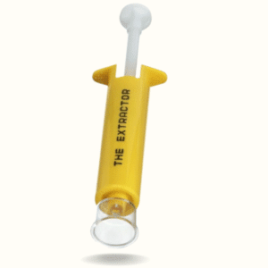
Prepare for the bugs now with our Bug Bite Extractor. This portable, easy-to-use venom and irritant vacuum pump sucks away the nasties that leave you miserable. It works on mosquitoes, bees, wasps, and more, and is compact, lightweight, and reusable.


